


Outdooractive. Hike and Ride

Description of Outdooractive. Hike and Ride
আউটডোরঅ্যাকটিভ - হাইক এবং রাইডের সাথে দুর্দান্ত আউটডোরে আত্মবিশ্বাসের সাথে অন্বেষণ করুন: সবচেয়ে নির্ভরযোগ্য আউটডোর নেভিগেশন অ্যাপ, যা বিশ্বব্যাপী হাজার হাজার ট্রেইল ওয়ার্ডেন, মাউন্টেন গাইড এবং আউটডোর শিল্প পেশাদারদের দ্বারা বিশ্বস্ত।
আউটডোর অ্যাকটিভ - হাইক অ্যান্ড রাইড অ্যাপ আপনাকে আপনার কাছাকাছি এবং বিশ্বজুড়ে অফিসিয়ালভাবে অনুমোদিত রুটগুলি খুঁজে পেতে সহায়তা করে, যার মধ্যে রয়েছে ডজন ডজন খেলাধুলার পরামর্শ সহ: হাইকিং পাথ, ট্রেকিং ট্রেইল, মাউন্টেন বাইকিং রুট, ট্রেইল রানিং পাথ, স্কি ট্যুরিং রুট এবং আরও অনেক কিছু। অথবা আপনার নিজের হাতে অ্যাডভেঞ্চার নিতে অফিসিয়াল মানচিত্রের গভীরতম ক্যাটালগ ব্যবহার করে আপনার নিজস্ব রুট পরিকল্পনা করুন।
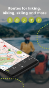
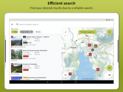
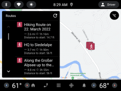
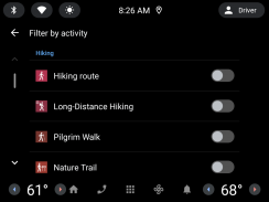
● আপনি নির্ভর করতে পারেন এমন রুট খুঁজুন: হাইকিং, রোড সাইক্লিং, বাইক ট্যুরিং, স্কি ট্যুরিং, গ্রেভেল রাইডিং, ট্রেইল দৌড়, ঘোড়ায় চড়া, পর্বতারোহণ এবং আরও অনেক কিছু সহ আপনার কাছাকাছি এবং সারা বিশ্বে হাজার হাজার সরকারীভাবে অনুমোদিত রুটগুলি ব্রাউজ করুন৷
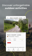
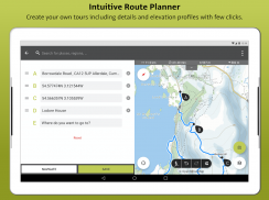
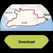
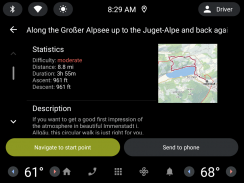
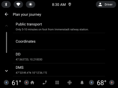
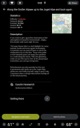
● পেশাদারদের দ্বারা বিশ্বস্ত সরঞ্জামগুলির সাহায্যে আপনার নিজস্ব রুট পরিকল্পনা করুন: রুট প্ল্যানারে শুধুমাত্র কয়েকটি ট্যাপে আপনার নিজের বহিরঙ্গন রুটগুলি সহজে প্লট করুন এবং দূরত্ব, উচ্চতা এবং ভূখণ্ডের তথ্য জানার প্রয়োজন দেখুন৷
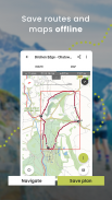
● সবকিছু অফলাইনে সংরক্ষণ করুন: আপনার কাছে ফোন সিগন্যাল না থাকলে নির্ভরযোগ্য নেভিগেশনের জন্য পৃথক প্ল্যান বা সমগ্র এলাকা অফলাইনে সংরক্ষণ করুন৷
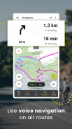
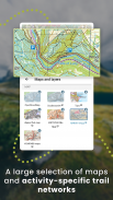
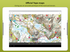
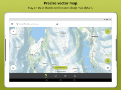
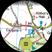
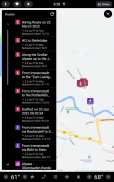
● গ্রহের সবচেয়ে নির্ভরযোগ্য মানচিত্রগুলির সাথে নেভিগেট করুন: আত্মবিশ্বাসের সাথে আপনার অ্যাডভেঞ্চারগুলি ট্র্যাক করতে বা পরিকল্পনা করতে বিভিন্ন ধরণের মানচিত্রের গভীরতম সংগ্রহ ব্রাউজ করুন৷ আপনি যে ভূখণ্ডটি পরিদর্শন করার পরিকল্পনা করছেন তার একটি পরিষ্কার ছবি পেতে এবং স্থলের অবস্থার সবচেয়ে নির্ভরযোগ্য ধারণা পেতে কেবল বিভিন্ন স্তরের মধ্যে স্যুইচ করুন৷ Outdooractive এর মানচিত্র ক্যাটালগে বর্তমানে অন্তর্ভুক্ত রয়েছে:
- 25টি দেশে অফিসিয়াল টোপো মানচিত্র, সহ:
• যুক্তরাজ্যের অর্ডন্যান্স সার্ভে (ল্যান্ডরেঞ্জার এবং এক্সপ্লোরার)
• NZ-এ নিউজিল্যান্ড ভূমি তথ্য
• মার্কিন যুক্তরাষ্ট্রে USGS
• জার্মানিতে বিকেজি
• অস্ট্রিয়াতে BEV
• সুইজারল্যান্ডের সুইসস্টোপো
• ফ্রান্সে IGN
• CNIG স্পেনে
• নেদারল্যান্ডে পিডিওকে
• নরওয়েতে কার্টভারকেট
• ডেনমার্কে কর্টফোরসিনিংজেন
সুইডেনে ল্যান্টমেটেরিয়েট
• ফিনল্যান্ডে ফিনল্যান্ড জাতীয় ভূমি জরিপ
• জাপানে জিএসআই
• যুক্তরাজ্যের সবচেয়ে পাহাড়ি এলাকায় হার্ভে মানচিত্র
- আল্পসে আরোহণের জন্য অফিসিয়াল আলপাইন ক্লাব মানচিত্র
- ফ্রান্স, জার্মানি, অস্ট্রিয়া এবং সুইজারল্যান্ড জুড়ে বিশেষভাবে ডিজাইন করা আউটডোর অ্যাকটিভ মানচিত্র।
● পরিবার এবং বন্ধুদের সাথে আপনার লাইভ অবস্থান ভাগ করুন: আপনি যখন বাইরের বাইরে থাকেন তখন নিজেকে এবং আপনার প্রিয়জনকে সম্পূর্ণ মানসিক শান্তি দিন, BuddyBeacon ধন্যবাদ৷
● বহিরঙ্গন পর্যটক এবং অভিযাত্রীদের একটি বৈশ্বিক সম্প্রদায়ে যোগ দিন: সম্প্রদায়ের সাথে আপনার ক্রিয়াকলাপগুলি ভাগ করুন, অনুপ্রাণিত থাকার চ্যালেঞ্জগুলিতে যোগ দিন এবং আমাদের হাজার হাজার শিল্প অংশীদারদের কাছ থেকে আনুষ্ঠানিকভাবে অনুমোদিত সামগ্রী দ্বারা অনুপ্রাণিত হন৷
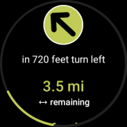
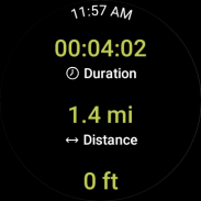
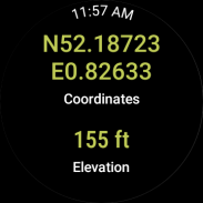
● Google থেকে WEAR OS সহ স্মার্টওয়াচগুলি: আপনার স্মার্টওয়াচের দিকে এক নজরে, আপনি মানচিত্রে আপনার GPS অবস্থান সম্পর্কে তথ্য পাবেন৷ আপনি ট্র্যাক রেকর্ড করতে পারেন, ট্র্যাকিং ডেটা পেতে এবং রুট বরাবর নেভিগেট করতে পারেন।
FAQs:
আউটডোরে কি আমার কাছাকাছি হাঁটার পথ খুঁজে পাওয়া যাবে?
আউটডোর অ্যাক্টিভ আপনাকে আপনার এলাকায় এবং সারা বিশ্বে হাঁটা, হাইকিং, সাইকেল চালানো এবং আরও অনেক ধরনের পথ খুঁজে পেতে সাহায্য করে।
আমি কিভাবে আমার কাছাকাছি হাইকিং ট্রেল খুঁজে পেতে পারি?:
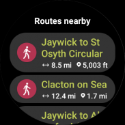
Outdooractive ব্যবহার করে, আপনি আমাদের অ্যাপ খুলে ম্যাপ ব্রাউজ করে আপনার স্থানীয় এলাকায় হাইকিং ট্রেইল খুঁজে পেতে পারেন। আপনি আপনার অবস্থান থেকে দূরত্ব, অসুবিধা এবং দূরত্বের একটি পরিসীমা সহ হাইকিং ট্রেল দেখতে সক্ষম হবেন।
আমি কীভাবে জানব যে আমার কাছাকাছি কোন হাইকিং ট্রেইলগুলি অনুসরণ করা ভাল?:
Outdooractive এর একাধিক মানচিত্র স্তর ব্যবহার করে, আপনি একাধিক উত্স থেকে অফিসিয়াল তথ্য দেখতে পারবেন, আপনাকে ট্রেইল শর্ত, নিয়ম, বিধিনিষেধ এবং আপনার ভ্রমণে কী আশা করতে হবে সে সম্পর্কে অবহিত করতে পারবেন। বিশেষজ্ঞরা প্রতিটি রুটের অসুবিধা, প্রয়োজনীয় অভিজ্ঞতার স্তর এবং আরও অনেক কিছু সম্পর্কে তথ্য ভাগ করবেন!
আমি কি অফলাইন ম্যাপ ডাউনলোড করতে পারি নেভিগেট করার জন্য প্রকৃতির হাঁটা এবং আমার কাছাকাছি হাইক করার জন্য এলাকা?:
আউটডোরঅ্যাকটিভ আপনাকে বাইরে যাওয়ার আগে আপনার ডিভাইসে মানচিত্র এবং রুটগুলি ডাউনলোড করতে দেয়, যেখানে সিগন্যালের গ্যারান্টি দেওয়া হয় না সেগুলি নেভিগেট করতে সাহায্য করার জন্য — আপনাকে নির্ভরযোগ্যভাবে বাইরে নেভিগেট করতে দেয়৷
Outdooractive. Hike and Ride - Version 3.20.4
(08-05-2025)
Outdooractive. Hike and Ride - APK Information
APK Version: 3.20.4Package: com.outdooractive.OutdooractiveLatest Version of Outdooractive. Hike and Ride
Other versions


Apps in the same category

You may also like...


